US Virgin Islands (USVI) Yacht Charter Guide: St. Thomas, St. John & Skipper Tips
A US Virgin Islands (USVI) yacht charter offers one of the most protected, scenic, and beginner-friendly sailing experiences in the Caribbean, tracing the vibrant harbors of St. Thomas and the untouched tropical forests of St. John. As part of the Virgin Islands archipelago, the USVI features world-class cruising grounds characterized by short, line-of-sight crossings, steady trade winds, and deep-water anchorages. Cruising these historic waters requires active awareness of seasonal wind spikes, understanding the strict mooring rules of the Virgin Islands National Park, and competence in picking up mooring buoys rather than anchoring. For travelers planning a Caribbean escape, chartering a private vessel—whether a stable catamaran ideal for hosting groups in wide bays or a classic monohull built to carve through Pillsbury Sound—is the ultimate way to explore. Weekly bareboat charters typically range from $4,000 to $12,000 depending on the season, while hiring a professional local captain adds roughly $1,500 to $2,000 per week, providing essential pilotage, mooring navigation, and local knowledge. If you are preparing for your first private cruise, be sure to read our guide on what to expect from a crewed yacht charter to understand the best options for your group, or explore our adjacent BVI yacht charter guide for a comparison of the neighboring British Virgin Islands.
Key Takeaways
- National Park Moorings: The Virgin Islands National Park strictly prohibits anchoring in most bays of St. John to protect coral reefs and seagrass beds, requiring skippers to use overnight mooring buoys.
- Beginner-Friendly Cruising: Protected by surrounding islands, the waters of Pillsbury Sound offer flat sea states and predictable trade winds, making the USVI excellent for family cruises and intermediate sailors.
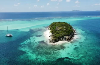
- Pizza Pi Yacht: A famous floating pizza boat anchored in Christmas Cove at Great St. James island provides a unique dining option accessible only by dinghy or boat.
⚓ USVI Cruising Vitals
| Best Cruising Months | Avg. Weekly Cost | Difficulty Level | Primary Winds & Currents | License Required? |
|---|---|---|---|---|
| December–April (Winter peak) | $4,000–$12,000 (bareboat) + $1,500–$2,000 (captain) | Beginner to Intermediate | Easterly trade winds (15-22 kts); “Christmas Winds” in Dec-Feb can hit 25-30 kts | No official license required by law, but charter companies require a detailed sailing resume |
Cruising the USVI: The Three Primary Sailing Zones
The US Virgin Islands consist of three main islands, each offering distinct geographical features, anchoring strategies, and shoreside atmospheres.
1. St. Thomas (Bustling Harbors & Staging)
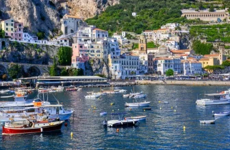
St. Thomas is the primary logistics hub, home to Charlotte Amalie, one of the deepest natural harbors in the Caribbean. This zone features world-class marinas like Yacht Haven Grande and Compass Point Marina. Cruising St. Thomas includes exploring Water Island (just off the harbor) and the East End near Red Hook, which serves as the gateway to Pillsbury Sound. Provisioning options are excellent here, with large supermarkets offering direct delivery to your charter dock.
2. St. John (National Park & Wilderness)
More than 60% of St. John is protected by the Virgin Islands National Park, making it a paradise of undeveloped forests, white sand coves, and pristine reef systems. The North Shore (including Maho Bay, Cinnamon Bay, and Trunk Bay) is highly protected from waves, offering flat, sandy mooring grounds. Cruising here is focused on snorkeling, hiking, and enjoying quiet nights under the stars. Anchoring is strictly banned in these bays, and skippers must pick up the white-and-blue park mooring buoys.
3. St. Croix (Open Ocean Passage)
St. Croix lies approximately 35 miles south of St. Thomas, separated by the deep Virgin Islands Trough. Sailing to St. Croix requires a long, open-ocean crossing (4–6 hours) across deep waters, which can feature heavy Atlantic swells. Once there, skippers will find the historic town of Christiansted and the Buck Island Reef National Monument, offering world-class diving. Due to the distance and open-water passage, St. Croix is best suited for 10-to-14-day charters and experienced crews.
A 7-Day St. Thomas & St. John Itinerary
This classic one-week cruising itinerary covers the best of St. Thomas and St. John, focusing on protected national park coves, marine sanctuaries, and local beach towns.
Disclaimer: Boating conditions, weather, and regulations change rapidly. Always cross-check with local authorities, official weather services, and paper charts before embarking.
Day 1: St. Thomas (Yacht Haven Grande) to Water Island (Druif Bay)
Sailing Distance: ~4 nautical miles
Depart your charter base at Yacht Haven Grande in Charlotte Amalie in the early afternoon. Perform a quick shake-down sail southwest across the harbor mouth to Druif Bay on Water Island. Drop anchor in 12–15 feet of water over clean sand. The holding here is excellent. Dinghy ashore to the beach, enjoy a local rum punch at the Dinghy’s Beach Bar, and watch the spectacular sunset over the Caribbean Sea.
Day 2: Water Island to Great St. James (Christmas Cove)
Sailing Distance: ~8 nautical miles
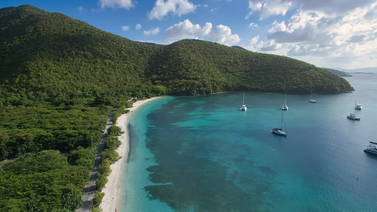
Weigh anchor and sail east along the scenic south coast of St. Thomas. Navigate Pillsbury Sound, taking care as you cross the ferry routes between Red Hook and Cruz Bay. Set a course for Christmas Cove, a sheltered marine sanctuary on Great St. James Island. Secure one of the public mooring buoys. Spend the afternoon snorkeling along the rocky reef, where you can swim with spotted eagle rays and sea turtles. For dinner, order a fresh hot pizza from Pizza Pi, the famous floating pizza boat, and have it delivered directly to your yacht’s stern.
Day 3: Christmas Cove to Maho Bay (St. John)
Sailing Distance: ~6 nautical miles
Cast off your mooring and sail northeast across Pillsbury Sound toward the lush green hills of St. John. Sail along the North Shore, passing Caneel Bay and Cinnamon Bay. Enter the calm waters of Maho Bay. Pick up a National Park mooring buoy in 10–12 feet of water. Maho Bay is famous for its shallow, warm waters and extensive seagrass beds. Snorkel directly from your swim platform to swim alongside green sea turtles and stingrays grazing in the shallows.
Day 4: Maho Bay to Coral Bay (St. John)
Sailing Distance: ~12 nautical miles
Weigh anchor early and sail east around the rugged, windward East End of St. John. Watch for increased swells as you exit the shelter of the North Shore. Navigate past Ram Head and sail into the wide expanse of Coral Bay. Secure a mooring or anchor in the inner bay. Coral Bay offers a laid-back, bohemian contrast to the busier Cruz Bay. Dinghy ashore to explore the local shops, visit Skinny Legs restaurant for a famous burger, and chat with local sailors.
Day 5: Coral Bay to Leinster Bay & Waterlemon Cay
Sailing Distance: ~8 nautical miles
Cast off your lines and sail north along the East End, heading back to the northern shore. Navigate into Leinster Bay and secure a National Park mooring buoy. Grab your snorkel gear and swim out to Waterlemon Cay, widely regarded as the best reef snorkeling spot in the USVI. You will see a vibrant ecosystem of brain coral, sea fans, parrotfish, and occasional reef sharks. In the late afternoon, walk the shoreline trail to the historic ruins of the Annaberg Sugar Plantation.
Day 6: Leinster Bay to Cruz Bay & Caneel Bay
Sailing Distance: ~7 nautical miles
Sail west along the North Shore. Stop for lunch at Trunk Bay by picking up a day-use mooring buoy, and swim along the underwater snorkeling trail complete with plaques describing the coral life. Continue sailing west to Cruz Bay, the main town of St. John. Pick up an overnight buoy in the outer harbor or head to Caneel Bay. Dinghy into the Cruz Bay town dock to explore the boutiques, art galleries, and waterfront cocktail bars.
Day 7: Cruz Bay back to St. Thomas (Yacht Haven Grande)
Sailing Distance: ~10 nautical miles
Enjoy your final breakfast aboard. Cast off the mooring line and sail west across Pillsbury Sound back toward St. Thomas. Navigate Pillsbury Sound, catching the steady morning trade winds for a spirited final sail. Sail past the south coast of St. Thomas, return to Yacht Haven Grande, refuel your catamaran at the dock, and conclude your USVI yachting adventure.
Ready to experience these pristine Caribbean waters? You can browse yacht charters on WeBoating.com to compare monohulls and catamarans and hire a professional captain for your USVI cruise.
Itinerary 2: The St. Croix Open-Ocean Passage (7 Days)
This offshore itinerary is designed for experienced crews seeking blue-water sailing, crossing the deep waters south to St. Croix to explore historic Christiansted and the Buck Island Reef National Monument.
Day 1: St. Thomas (Yacht Haven Grande) to Great St. James (Christmas Cove)
Sailing Distance: ~6 nautical miles
Cast off from Yacht Haven Grande and sail east along the south coast of St. Thomas. Navigate Pillsbury Sound, watching out for ferry traffic. Enter Christmas Cove on Great St. James Island. Secure a public mooring buoy in 12 feet of water. Spend the afternoon snorkeling over the reef and order a fresh hot pizza from the Pizza Pi floating boat.
Day 2: Great St. James to St. Croix (Christiansted)
Sailing Distance: ~35 nautical miles
Weigh anchor at dawn for a long, sporty open-ocean crossing south across the Virgin Islands Trough. This deep passage features consistent easterly trade winds and rolling ocean swells (typically 4-6 feet), demanding active helming and reefing. Navigate carefully through the outer reef channel into Christiansted Harbor. Dock at a local marina or anchor in the harbor basin in 15 feet of mud and sand.
Day 3: Christiansted to Buck Island Reef National Monument
Sailing Distance: ~6 nautical miles
Enjoy a short morning sail east to Buck Island, a federally protected uninhabited island. Secure one of the day-use mooring balls off the island’s spectacular barrier reef. Snorkel the legendary underwater trail along the Elkhorn coral reefs, which is home to turtles, rays, and thousands of tropical fish. In the afternoon, return to Christiansted to explore the historic Danish fort.
Day 4: Christiansted to Frederiksted
Sailing Distance: ~20 nautical miles
Sail west-southwest along the scenic northern shore of St. Croix, passing the steep cliffs of Salt River Bay. Round the northwest point and sail south to Frederiksted. Drop anchor in the sandy bottom off the town pier in 15 feet of clear water. The water here is exceptionally clear, making it a popular spot for snorkeling around the pier columns to spot seahorses and sea turtles.
Day 5: Frederiksted to Salt River Bay
Sailing Distance: ~16 nautical miles
Cast off and sail north-northeast back along the northern coast. Navigate into the protected lagoon of Salt River Bay National Historical Park. Anchor in the sandy basin in 10 feet of water. Salt River Bay is historically significant as the site of Christopher Columbus’ landing in 1493, and features a unique bioluminescent bay that can be explored by dinghy or kayak at night.
Day 6: Salt River Bay back to Water Island (Druif Bay)
Sailing Distance: ~35 nautical miles
Prepare for your return passage north across the open ocean. Cast off at dawn and sail north-northwest toward St. Thomas. This is a comfortable broad reach in the easterly trade winds. Arrive off St. Thomas and drop anchor in the clean sandy bottom of Druif Bay on Water Island in 12 feet of water. Celebrate your offshore crossing with a cold drink ashore.
Day 7: Water Island back to Yacht Haven Grande
Sailing Distance: ~4 nautical miles
Weigh anchor and sail a short distance east across Charlotte Amalie harbor back to Yacht Haven Grande. Refuel your catamaran, complete your vessel check-out, and conclude your St. Croix offshore cruise.
Yachting Infrastructure: USVI Marinas & Mooring Fields
Sailing in the US Virgin Islands features modern mega-yacht facilities alongside highly regulated national park mooring grids:
Yacht Haven Grande (St. Thomas): Located in Charlotte Amalie, this is one of the premier marina facilities in the Caribbean, designed to accommodate superyachts up to 200m. It offers full services, high-power shore power, potable water, waste pump-out, a swimming pool, and high-end shopping and dining within the marina complex.
Compass Point Marina (St. Thomas): Tucked into a highly sheltered mangrove lagoon on the south shore, this marina is a safe haven for local and charter boats, offering diesel mechanics, provisioning, and water services at lower rates than Charlotte Amalie.
Virgin Islands National Park Moorings (St. John): The national park maintains over 150 mooring buoys across bays like Maho, Francis, Leinster, and Caneel. Anchoring is strictly prohibited in these areas to protect coral and seagrass. The fees are paid via self-registration envelopes at stations located near the beaches or online. White buoys with a blue stripe are for overnight use, while red buoys are commercial and yellow/blue-striped buoys are day-use only.
🌪️ Weather Guardrails & Caribbean Winds
Sailing safely in the USVI requires an understanding of seasonal wind patterns and regional weather alerts:
- The Trade Winds & Christmas Winds: The primary wind system is the trade winds, blowing consistently from East/Northeast. In winter (December through February), the “Christmas Winds” can build, bringing sustained wind speeds of 25–30 knots and large ocean swells that can last for several days. Skippers must reef sails early and seek shelter in south-facing bays.
- Hurricane Season: The North Atlantic and Caribbean hurricane season runs from June 1 to November 30. The peak risk occurs in August and September. Charter companies operate with strict hurricane protocols, and skippers must monitor weather updates via NOAA and local marine channels daily.
- North Swells: During winter months, large swells generated by low-pressure systems in the North Atlantic can travel south, creating heavy breakers on the north shores of St. Thomas and St. John. Even in calm winds, these swells can make north-facing bays like Trunk Bay dangerous and uncomfortable for mooring.
Local Rules, Mooring & Environmental Regulations
USVI environmental and maritime authorities strictly enforce safety and conservation regulations:
– Seagrass & Turtle Conservation: Green sea turtles are protected under federal law. When mooring in bays like Maho Bay, skippers must maintain slow speeds and ensure dinghies do not strike turtles surfacing for air. Anchoring in seagrass is strictly prohibited, and anchors must only be dropped in clear sandy areas.
– Customs and Border Protection: If you plan to sail across the border into the neighboring British Virgin Islands (BVI), you must clear out of the USVI at Cruz Bay (St. John) or Charlotte Amalie (St. Thomas), and clear into the BVI at Jost Van Dyke or Tortola. Returning requires clearing back into the US via the CBP Roam app or in person.
– FACILITATOR Facilitating Role: WeBoating.com is a marketplace connecting travelers with independent, third-party operators. WeBoating does not operate, manage, or own any charters or experiences.
Glossary: Speak Like a Virgin Islands Skipper
Pillsbury Sound: The body of water between St. Thomas and St. John, known for its steady trade winds and excellent sailing conditions.
Christmas Winds: Accelerated, cool trade winds (20–30 knots) that occur in the Caribbean during the winter months.
National Park Buoy: An overnight mooring buoy maintained by the National Park Service to prevent anchor damage to reefs.
Frequently Asked Questions About USVI Yacht Charters
The prime charter season runs from December through April, offering warm weather, consistent trade winds, and dry conditions. May to November is the wetter, warmer period, with the official Atlantic hurricane season extending from June 1 through November 30.
No official sailing license is required for bareboat charters in the USVI. However, charter operators require a detailed sailing resume showing experience on similar-sized vessels. If your resume is not approved, you will be required to hire a captain.
Yes. The national park in St. John requires yachts to pay a daily moorage fee (typically $26 USD per night) when using park mooring buoys. Payments can be made at self-service pay stations located onshore in major bays or via the pay.gov portal.
Yes, but you must comply with customs and immigration rules for both territories. You must check out of the USVI (typically in Cruz Bay, St. John) and clear into the BVI at a designated port of entry (like Soper’s Hole, Tortola). A valid passport is required.
The Christmas Winds are strong, consistent trade winds (20-30+ knots) that blow from the east-northeast during December and January. They bring sporty sailing conditions, larger ocean swells, and occasional brief rain squalls, requiring reefed sails and active seamanship.
Most charters depart from St. Thomas, specifically Yacht Haven Grande or Compass Point Marina, which offer full services and provisioning.
No, anchoring is prohibited in most bays of the park to protect coral reefs. You must use the national park mooring buoys.
The tidal range is very small, typically around 8 to 12 inches (20-30 cm), making tide calculations unnecessary for most navigation.
You can expect to see green sea turtles, hawksbill turtles, spotted eagle rays, nurse sharks, and vibrant coral formations at Buck Island or Maho Bay.
St. Croix is located about 35 miles south of St. Thomas across an open-ocean passage, so it requires a dedicated crossing and is not suitable for a day trip.
When crossing between the USVI and BVI, all passengers must carry valid passports and clear customs and immigration at designated ports of entry.
You can compare and book yacht charters directly on WeBoating.com, where you can select a catamaran or monohull and hire a professional captain for your cruise.