Bahamas Yacht Charter Guide: Abaco Islands Sailing Itinerary & Skipper Tips

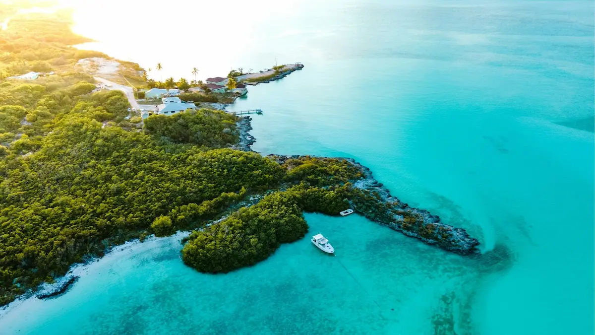
A Bahamas yacht charter offers one of the most celebrated shallow-water cruising experiences in the world, renowned for its powder-soft sandbanks, historic settlements, and vibrant marine parks. The Abaco Islands—a 120-mile-long crescent of barrier cays surrounding the shallow Sea of Abaco—serve as the yachting capital of the Bahamas. Cruising here combines steady trade winds and sheltered waters with a relaxed, island-hopping rhythm. However, navigating the Bahamas requires active seamanship, careful calculation of a 2 to 3-foot tidal range, and the ability to perform visual “eyeball navigation” over shifting sandbanks. For travelers planning a tropical island getaway, chartering a private vessel—whether a spacious catamaran ideal for skimming over shallow reefs or a classic monohull designed for comfortable trade-wind passages—is the ultimate way to explore the cays. Weekly bareboat charters typically range from $4,500 to $12,000, while hiring a professional local captain adds approximately $1,500 to $2,000 per week, providing essential knowledge of shallow channels, ocean passes, and secluded mooring spots. If you are preparing for a yacht charter, read our guide on what to expect from a crewed yacht charter to select the best option for your crew, or check out our adjacent Croatia yacht charter guide for a Mediterranean comparison.
Key Takeaways
- Shallow Draft Cruising: The Sea of Abaco is shallow, with average depths of 5–15 feet. Low-draft vessels—particularly catamarans drawing under 4 feet—are heavily preferred for safety and accessibility.
- Eyeball Navigation: Due to shifting sandbars and coral heads, skippers must learn to read water depth visually (e.g., white/yellow is shallow sand, brown is reef/coral, blue is deep water).
- Ocean Pass “Rages”: Entering or exiting the ocean passes (such as Whale Cay Passage) must be timed with slack tide and calm winds to avoid dangerous breaking seas known as “rages.”
⚓ Bahamas Cruising Vitals
| Best Cruising Months | Avg. Weekly Cost | Difficulty Level | Primary Winds & Currents | License Required? |
|---|---|---|---|---|
| November–June (May-June sweet spot) | $4,500–$12,000 (bareboat) + $1,500–$2,000 (captain) | Intermediate | NE trade winds (winter, 15-20 kts); SE trade winds (summer, 10-15 kts) | No (Sailing Resume checked by charter operator; ICC recommended) |
Cruising the Abacos: The Three Primary Sailing Zones
The Abaco Islands feature a unique geographical layout, split into distinct zones that dictate your routing, anchoring depth, and passage planning.
1. The Sea of Abaco (Sheltered Sound)
The Sea of Abaco is a shallow, protected body of water sandwiched between the mainland of Great Abaco and a protective outer barrier reef of cays. This sound offers relatively flat-water sailing, protecting yachts from the heavy ocean swells of the open Atlantic. Sailing here is comfortable and visually stunning, but the bottom is shallow. Skippers must keep a close watch on the depth sounder and tide tables, as large areas average only 6 to 10 feet of depth at low tide.
2. The Outer Barrier Cays
A chain of small reef islands (cays) borders the eastern edge of the Sea of Abaco. These cays host historic, colorful loyalist settlements like Hope Town on Elbow Cay (famous for its candy-striped lighthouse) and Man-O-War Cay (the traditional boatbuilding center of the Bahamas). The cays are spaced short distances apart (typically 5 to 10 NM), allowing for easy day-tripping and anchoring in protected harbors or off gorgeous sandy beaches like Tahiti Beach.
3. The Ocean Passes & Whale Cay Passage
Because the outer cays form a continuous wall, sailing between the northern and southern halves of the sound requires exiting into the open Atlantic through deep-water passes and sailing around Whale Cay before returning inside. Whale Cay Passage is the most famous of these ocean passes. When strong winds oppose a surging tide, these passes experience a dangerous phenomenon called a “rage,” creating steep, breaking seas that are unsafe for leisure craft. Skippers must plan these transits carefully based on weather forecasts and tide windows.
A 7-Day Abaco Islands Yacht Charter Itinerary
This classic week-long sailing route begins and ends in Marsh Harbour, looping through the central and northern cays of the Sea of Abaco to experience historic towns, wildlife-rich marine parks, and pristine beaches.
Disclaimer: Boating conditions, weather, and regulations change rapidly. Always cross-check with local authorities, official weather services, and paper charts before embarking.
Day 1: Marsh Harbour to Man-O-War Cay
Sailing Distance: ~6 nautical miles
Depart your charter base in Marsh Harbour in the early afternoon, setting a course northeast across the Sea of Abaco. Keep a sharp eye on your draft as you navigate the channels. Slide into the narrow, highly protected harbor of **Man-O-War Cay** and secure your vessel to a rental mooring buoy. Walk the quiet, car-free streets of this historic loyalist settlement, explore the wooden boatbuilding yards, and visit Albury’s Sail Shop to purchase traditional hand-sewn canvas bags.
Day 2: Man-O-War Cay to Great Guana Cay
Sailing Distance: ~8 nautical miles
Enjoy a short morning sail north to Great Guana Cay. Drop anchor in the wide, sandy basin of **Fisher’s Bay** or Settlement Harbour in 6–8 feet of water. The holding is excellent in soft sand. Take the tender ashore and walk across the narrow island to **Nipper’s Beach Bar & Grill**, perched on a high dune overlooking a massive Atlantic barrier reef. Spend the afternoon snorkeling the reef, swimming in the pools, and enjoying the lively beachside atmosphere.
Day 3: Great Guana Cay to Green Turtle Cay
Sailing Distance: ~14 nautical miles
Prepare for the most technical leg of the charter. To sail north of Whale Cay, you must exit through the reef into the open Atlantic, sail past the island, and return to the sound through the **Whale Cay Passage**. Time this transit for a slack tide and avoid it if a strong Norther or northeast wind is blowing. Once safely back inside, head to Green Turtle Cay and anchor or secure a slip in **Black Sound** or **White Sound**. Explore the historic, 18th-century loyalist village of New Plymouth.
Day 4: Green Turtle Cay to Treasure Cay
Sailing Distance: ~10 nautical miles
Sail south back across the Whale Cay Passage under comfortable afternoon trade winds. Set a course for **Treasure Cay Beach**, widely rated as one of the most beautiful crescent beaches in the world. Drop anchor in the spacious bay in 8–10 feet of water over clean, sticky white sand. Spend the day walking the 3.5 miles of powder-soft sand and swimming in the calm, turquoise water.
Day 5: Treasure Cay to Elbow Cay (Hope Town)
Sailing Distance: ~15 nautical miles
Enjoy a spirited sail southeast down the Sea of Abaco. Navigate carefully through the shallow, buoyed entrance channel into **Hope Town** on Elbow Cay. Hope Town’s harbor is a strictly engine-free zone for sailing; secure your vessel to a public mooring buoy or dock at the Hope Town Inn & Marina. Visit the iconic, hand-cranked **Elbow Reef Lighthouse**, built in 1863, and climb its 101 steps for a panoramic view of the sound.
Day 6: Hope Town to Little Harbour
Sailing Distance: ~14 nautical miles
Cast off your mooring and sail south. Stop at the gorgeous sandbar of **Tahiti Beach** for a mid-day swim. Continue south, sailing through the protected waters of the Pelican Cays Land and Sea Park, which offers world-class reef snorkeling. Enter **Little Harbour**, a nearly landlocked, shallow basin at the southern end of the cruising ground. Grab a mooring buoy and dine at **Pete’s Pub & Gallery**, an off-grid, open-air beach bar famous for its fresh fish and working bronze art foundry.
Day 7: Little Harbour back to Marsh Harbour
Sailing Distance: ~12 nautical miles
Weigh anchor and sail north along the eastern shoreline of Great Abaco. Catch the morning trade winds to enjoy a comfortable broad reach. Keep an eye out for bottlenose dolphins and sea turtles in the shallow waters. Complete your cruise by returning to Marsh Harbour, refueling at the dock, and checking out at the charter base.
Ready to plan your escape? You can browse yacht charters on WeBoating.com to compare bareboat or skippered catamarans and book your Bahamas cruise.
Bahamian Marine Infrastructure: Ports & Marinas
The Abacos feature well-developed yachting infrastructure, recovery from past hurricanes is complete, and full services are available across the cays:
Marsh Harbour Charter Hubs: Marsh Harbour is the commercial hub. Marinas like **Conch Inn Marina** (home base for The Moorings and Sunsail) and **Harbour View Marina** offer full-service slips, shore power, water, ice, fuel, and laundry. Excellent provisioning is available at Maxwell’s Supermarket, a large US-style grocery store located a short taxi ride from the docks.
Hope Town Inn & Marina (Elbow Cay): Located on the eastern side of Hope Town’s harbor, directly opposite the historic lighthouse. It offers high-quality concrete slips, water, power, and access to a freshwater swimming pool, bar, and restaurant. The harbor also contains dozens of public mooring buoys managed by local caretakers.
Green Turtle Club & Marina (Green Turtle Cay): Situated in White Sound, this historic resort-style marina features state-of-the-art docks, fuel (gas and diesel), fresh water, laundry, and a famous colonial-style bar draped in dollar bills signed by visiting sailors.
🌪️ Weather Guardrails & Bahamian Winds
Sailing safely in the Bahamas requires a detailed understanding of tropical weather patterns and seasonal trade winds:
- Hurricane Season: The North Atlantic and Caribbean hurricane season runs from June 1 to November 30. August, September, and October carry the highest risk of tropical systems. Most charter companies close during these months, and skippers must avoid chartering due to lack of storm shelter in the shallow cays.
- Christmas Winds: From December through February, the trade winds accelerate, blowing consistently from the ENE at 20–25 knots (locally called the “Christmas Winds”). Skippers must be comfortable reefing sails and managing constant swells in open sound passages.
- Winter Northers: During the winter months, cold fronts sweeping off the US mainland can reach the Bahamas, causing winds to shift suddenly to the northwest or north and gust up to 30–35 knots. These “Northers” can drop air temperatures rapidly and create a dangerous “rage” (heavy breaking seas) in north-facing ocean passes.
Local Rules, Mooring Fees & Tide Ranges
Cruising in the Bahamas requires compliance with local marine park rules and careful navigation in shallow waters:
– Tidal Range Navigation: While the tide range in the Bahamas is modest (typically 2 to 3 feet), it is critical in a shallow sound where many channels and bays are only 5 to 7 feet deep. A catamaran with a 3.5-foot draft can easily ground if anchoring in a 5-foot bay at high tide; always calculate the low-water clearance before dropping anchor.
– Customs & Cruising Permits: If chartering from a local base, your permit is handled by the operator. For private arrivals, the captain must clear customs immediately at a Port of Entry using the Click2Clear system. Cruising fees for a 31-50ft vessel are $250 for a 30-day permit.
– Marine Reserves & Fishing: Pelican Cays Land and Sea Park is a strict marine sanctuary where taking any marine life is prohibited. Spear fishing is banned within 200 yards of any cay, and using scuba gear to spear fish or harvest conch is illegal throughout the Bahamas.
Glossary: Speak Like an Abaco Skipper
Rage: A severe, breaking sea state occurring in narrow ocean passes, caused by heavy Atlantic swells meeting shallow sandbars or opposing tidal currents.
Cay: Derived from the Spanish word “cayo”, pronounced “key”, referring to a low-elevation, sandy island formed on top of a coral reef.
Eyeball Navigation: The essential practice of steering a vessel based on the visual color of the water ahead to determine depth and avoid shallow reefs or sandbars.
WeBoating.com is a marketplace connecting travelers with independent, third-party operators. WeBoating does not operate, manage, or own any charters or experiences.
Frequently Asked Questions About Bahamas Yacht Charters
The prime charter season runs from November through June. July through October is hurricane season, during which many charter bases close and weather risks are high. May and June are excellent shoulder months offering calmer winds and warmer water.
No formal government license is required for bareboat charters in the Bahamas. Charter operators require skippers to submit a sailing resume demonstrating experience on vessels of similar size and displacement in coastal waters.
Catamarans are highly preferred because they feature a shallow draft (typically 3 to 4 feet), allowing them to cross shallow sandbanks and enter protected bays that are inaccessible to deep-draft monohulls.
Eyeball navigation is the practice of reading water depth by color. Light blue or yellow water indicates shallow sandbars, brown indicates coral reefs or rocks, and dark blue indicates deep water. It is essential for navigating shallow Bahamian sounds.
A rage is a dangerous sea state in ocean passes where Atlantic swells break over shallow sandbars. It is triggered by wind opposing the tide or winter Northers. Avoid it by staying inside the sound or waiting for a calm tide window.
Yes. Protected harbors like Hope Town and Man-O-War Cay offer rental mooring buoys for $20 to $30 per night. These are highly recommended as anchoring is restricted in these narrow harbors.
Northers are cold fronts from the US mainland that sweep across the Bahamas in winter, shifting winds to the north or northwest at 25–35 knots. They bring cooler temperatures, strong winds, and rough seas in ocean passes.
You can browse yacht charters on WeBoating.com to compare catamarans and monohulls, with or without a professional captain, departing from bases like Marsh Harbour.