San Juan Islands Yacht Charter Guide: Orcas Island Itinerary & Skipper Tips

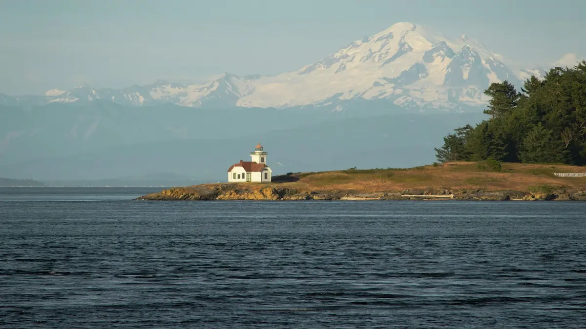
A San Juan Islands yacht charter provides a world-class sailing experience in the Pacific Northwest, nestled within the rain shadow of the Olympic Mountains and boasting dramatic pine-covered shorelines and abundant marine wildlife. The best time to sail the San Juan Islands is from June through September when the region is warmest and driest, while a weekly bareboat monohull or catamaran charter typically ranges from $4,000 to $9,000, and no formal sailing license is legally required if you submit a verified boating resume demonstrating cold-water tidal navigation. Because of the extreme tidal ranges (8 to 14 feet) and fast-moving currents, skippers must plan their passages carefully around the tides. If you are comparing Pacific Northwest cruising grounds, view our adjacent Gulf Islands yacht charter guide or our British Columbia yacht charter guide to map your perfect coastal voyage.
Key Takeaways
- Tidal Current Gateways: Navigating narrow passes like Obstruction Pass or Thatcher Pass requires timing your transit to match slack water to avoid strong currents.
- Submerged Rock Vigilance: The region is famous for hidden pinnacle rocks and kelp beds, requiring close monitoring of depth sounders and updated charts.
- Whale Standoff Rules: Cruising under local wildlife protection laws requires keeping a minimum 300-yard distance from Southern Resident Killer Whales (Orcas).
⚓ Quick Facts & Experience Vitals
| Best Time to Go | Avg. Weekly Cost | Difficulty Level | Key Winds / Currents | License Required? | Primary Embarkation Port |
|---|---|---|---|---|---|
| June–September (Olympic Rain Shadow dry season) | $4,000–$9,000 (bareboat) + $1,800–$2,800 (skipper) | Advanced (Extreme tides, currents, logs, fog) | S/SW winds (5-15 kts); currents (3-6 kts) in narrow passes | No (Sailing resume showing tidal experience required) | Anacortes / Friday Harbor / Bellingham |
The Lay of the Land (Introduction)
Cruising the San Juan Islands is a feast for the senses, defined by deep glacially carved fjords and dense forests of cedar, Douglas fir, and red-barked madrona trees. As you sail through the islands, the scent of pine sap and cold salt water drafts off the shoreline, mixed with the rich smell of tidal kelp beds. In the early morning, bald eagles call from the tops of hemlock trees while harbor seals watch your progress from rocky reefs. The water remains cold year-round, displaying a deep jade green color, while the Olympic Mountains form a spectacular snow-capped wall to the south. From the bustling, historic docks of Friday Harbor to the dramatic sandstone formations of Sucia Island, the archipelago offers a sheltered cruising ground with a rugged frontier spirit.
Sailing Zones / Cruising Sectors
The San Juan archipelago is divided into three distinct cruising sectors, each defined by unique tidal exposures and shoreside amenities:
1. San Juan Channel & Central Islands
This central sector is the commercial and social heart of the islands, containing San Juan Island, Orcas Island, and Shaw Island. Navigating here requires managing tidal flows in the San Juan Channel, which separates San Juan from Lopez. The zone features major resort harbors like Friday Harbor and Roche Harbor, offering excellent provisioning, transient slips, and protection from all wind sectors.
2. Rosario Strait & Lopez Island
Exposed to the open waters of the Strait of Juan de Fuca to the south, this eastern sector features Lopez Island, Cypress Island, and Guemes Island. Rosario Strait is a major commercial shipping lane, requiring skippers to monitor vessel traffic services. Winds here are more consistent, providing excellent sailing breeze, while anchorages like Spencer Spit offer classic sandy holding.
3. Boundary Pass & Northern Outposts
Bordering the Canadian Gulf Islands, this northern sector features Sucia Island, Patos Island, and Matia Island. These islands are protected marine state parks with no permanent residents. The waters of Boundary Pass can experience heavy chop when north-westerly winds blow against flood tides. Anchorages feature dramatic sandstone caves, clay cliffs, and deep mud holding.
Sailing Itineraries
Itinerary 1: The San Juan Islands Classic Loop (Anacortes Round-Trip, 7 Days)
This classic loop departs from Cap Sante Marina in Anacortes, offering a complete tour of the primary cays and resort harbors.
Day 1: Anacortes to Lopez Island (Spencer Spit)
Sailing Distance: ~12 nautical milesRouting Details: Cast off and head west across Guemes Channel, crossing Rosario Strait; watch for the commercial shipping lanes.
Anchoring & Staging: Hook a state park mooring buoy off Spencer Spit, or anchor in 15 feet of sand and mud; good holding.
Marine Highlights: Walk the sandy hook of Spencer Spit, explore the salt marsh Lagoon, and watch for blue herons.
Day 2: Lopez Island to Friday Harbor (San Juan Island)
Sailing Distance: ~10 nautical milesRouting Details: Sail west through Upright Channel, entering the San Juan Channel; watch for the Washington State ferries.
Anchoring & Staging: Secure a transient slip at Friday Harbor Marina, or anchor in the outer harbor in 25 feet of mud.
Marine Highlights: Visit the Whale Museum, shop local boutiques, and provisioning with fresh Pacific Northwest seafood.
Day 3: Friday Harbor to Roche Harbor
Sailing Distance: ~12 nautical milesRouting Details: Head north up San Juan Channel, turning west around Spieden Island where currents can exceed 4 knots.
Anchoring & Staging: Dock at Roche Harbor Marina, or anchor in Westcott Bay in 10 feet of sticky mud (excellent shelter).
Marine Highlights: Walk the historic Roche Harbor grounds, view the lime kiln ruins, and watch the evening colors ceremony.
Day 4: Roche Harbor to Sucia Island Marine State Park
Sailing Distance: ~15 nautical milesRouting Details: Sail northeast across Boundary Pass, entering the northern marine park; watch for driftwood logs in the channel.
Anchoring & Staging: Pick up a state mooring buoy in Fossil Bay, or anchor in Echo Bay in 18 feet of mud; sheltered from south winds.
Marine Highlights: Hike the trails to see the eroded honeycomb sandstone formations and search for fossils on the beaches.
Day 5: Sucia Island to Orcas Island (West Sound)
Sailing Distance: ~14 nautical milesRouting Details: Sail south past Orcas Island’s western shore, entering the deep indentation of West Sound.
Anchoring & Staging: Anchor in West Sound off Massacre Bay in 20 feet of mud, or secure a slip at West Sound Marina.
Marine Highlights: Kayak around Skull Island, and dine at the historic yacht club restaurant in West Sound.
Day 6: West Sound to Cypress Island (Eagle Harbor)
Sailing Distance: ~15 nautical milesRouting Details: Sail east through Obstruction Pass at slack water to cross Rosario Strait, heading toward Cypress Island.
Anchoring & Staging: Pick up a DNR mooring buoy in Eagle Harbor, or anchor in 25 feet of mud; open to easterly winds.
Marine Highlights: Hike up to Eagle Cliff for a panoramic view of Mount Baker and the entire San Juan archipelago.
Day 7: West Sound back to Anacortes
Sailing Distance: ~10 nautical milesRouting Details: Sail south along Cypress Island’s eastern coast, crossing Guemes Channel back to Anacortes base.
Anchoring & Staging: Return to your slip at Cap Sante Marina, complete vessel check-out.
Marine Highlights: Tour the historic marine heritage center in Anacortes and provisioning for departure.
Itinerary 2: The Northern Marine Parks Adventure (Bellingham Round-Trip, 7 Days)
An alternative route starting from Bellingham, exploring the wilder northern cays and isolated state parks.
Day 1: Bellingham to Lummi Island
Sailing Distance: ~10 nautical milesRouting Details: Cast off from Squalicum Harbor and sail southwest across Bellingham Bay; watch for shallow waters near the Nooksack delta.
Anchoring & Staging: Anchor in Inati Bay on the eastern side of Lummi Island in 20 feet of sand and mud; good holding.
Marine Highlights: Hike the Lummi Island trails and dine at local farm-to-table restaurants on the island.
Day 2: Lummi Island to Matia Island State Park
Sailing Distance: ~14 nautical milesRouting Details: Sail west-northwest through Hale Passage and across Rosario Strait, heading for the isolated Matia Island.
Anchoring & Staging: Anchor in the small, narrow cove of Rolfe Cove in 15 feet of mud (very limited space; only 2 mooring buoys).
Marine Highlights: Hike the loop trail through Matia’s ancient old-growth cedar forest, designated as a federal wilderness area.
Day 3: Matia Island to Sucia Island (Fossil Bay)
Sailing Distance: ~5 nautical milesRouting Details: Short morning hop west to Sucia Island; watch for reef pinnacles extending off the eastern tip of Sucia.
Anchoring & Staging: Anchor in Fossil Bay in 12 feet of mud, or secure your vessel to the state park dock.
Marine Highlights: Search the shale banks of Fossil Bay for ancient marine fossils, and paddleboard around the sandstone arches.
Day 4: Sucia Island to Patos Island State Park
Sailing Distance: ~6 nautical milesRouting Details: Sail northwest across the channel; watch the strong currents of Boundary Pass which run north toward the Strait of Georgia.
Anchoring & Staging: Anchor in Active Cove in 10 feet of mud; note that the entrance is narrow with strong cross-currents.
Marine Highlights: Tour the historic 1893 Patos Island Lighthouse, and walk the rugged cobblestone beaches of the northernmost outpost.
Day 5: Patos Island to Orcas Island (Rosario Resort)
Sailing Distance: ~18 nautical milesRouting Details: Sail south through East Sound, a long fjord-like bay that cuts deep into the heart of Orcas Island.
Anchoring & Staging: Dock at Rosario Resort Marina or anchor in Cascade Bay in 20 feet of mud; open to southerly winds.
Marine Highlights: Visit the historic Moran Mansion at Rosario, relax in the hot tubs, and hike up to Cascade Lake.
Day 6: Rosario Resort to Jones Island State Park
Sailing Distance: ~12 nautical milesRouting Details: Sail west out of East Sound, through Obstruction Pass, and west along the southern shore of Orcas to Jones Island.
Anchoring & Staging: Drop anchor in the northern bay of Jones Island in 15 feet of mud, or pick up a state mooring buoy.
Marine Highlights: Walk the 2-mile loop trail to see the resident, friendly black-tailed deer that come down to meet boaters.
Day 7: Jones Island back to Bellingham
Sailing Distance: ~28 nautical milesRouting Details: Head east through Thatcher Pass and across Rosario Strait, sailing back into Bellingham Bay.
Anchoring & Staging: Return to Squalicum Harbor, complete vessel check-out.
Marine Highlights: Celebrate your return with a craft beer in Bellingham’s historic Fairhaven district.
Local Berthing & Staging (Small Boat Harbors & Marinas)
Sailing in the Pacific Northwest relies on a mix of municipal small boat harbors and historic resort docks:
Friday Harbor Marina
The largest municipal marina in the islands, Friday Harbor offers over 100 guest slips for vessels up to 150 feet. It features full power, fresh water, fuel docks, pump-out stations, and a dedicated Customs and Border Protection check-in office. The harbor is extremely well protected from all wind directions by Brown Island, and the town offers exceptional provisioning and marine supply shops within walking distance.
Roche Harbor Resort & Marina
Situated on the northwest corner of San Juan Island, Roche Harbor is an upscale historic resort marina offering concrete floating docks for yachts up to 150 feet. It provides high-capacity fueling, fresh water, electricity, provisioning at the historic company store, and fine dining. The harbor is protected by Pearl Island, offering excellent safety from all wind sectors.
Rosario Resort Marina
Located in East Sound on Orcas Island, this marina features floating wooden docks for vessels up to 80 feet. It offers shore power, water, and access to the historic Moran Mansion pools and spa. The marina is open to the south, meaning strong southerly winds can create a rolly surge, making West Sound or Deer Harbor safer alternatives during storms.
Cap Sante Marina (Anacortes)
The primary embarkation base for the region, Cap Sante is a massive, modern municipal marina in Anacortes. It features state-of-the-art concrete docks, fuel stations, pump-outs, and multiple marine repair facilities. The marina is completely protected behind a solid breakwater, and it is located next to supermarkets and marine chandleries, making it the perfect staging point.
🌪️ Regional Weather Guardrails & Winds
Navigating the Pacific Northwest safely requires understanding complex wind funnels, seasonal weather changes, and extreme tidal mechanics:
- The Pineapple Express & Winter Storms: While summer is dry, late autumn and winter bring the “Pineapple Express,” an atmospheric river of warm, moisture-laden air that carries heavy rain and gale-force winds. Skippers must check bilge pumps, clear deck drains, and ensure high-capacity cabin heaters are operational before casting off.
- Rosario & Haro Strait Wind Funneling: Prevailing summer winds are S/SW, but the high topography of the islands causes winds to funnel through Rosario Strait and Haro Strait. Winds can accelerate from 10 knots to 25+ knots within hours, creating steep wind-against-current chops. Crews must monitor NOAA marine weather broadcasts on VHF Channel 4.
- Late Summer Fog: During August and September, warm summer air blowing over the cold waters of the Strait of Juan de Fuca creates dense marine fog. Visibility can drop to under 50 feet. Yachts must carry functional radar, GPS plotters, and sound signals (foghorns) to navigate the active shipping channels safely.
- Extreme Tidal Ranges & Current Gates: Astronomical tides range from 8 to 14 feet daily. The vast volume of water moving through narrow channels generates currents of 3 to 6+ knots (e.g., in Deception Pass or Spieden Channel). Slower sailing vessels must calculate transit gates to match slack water to prevent being swept off course or trapped in tide rips and whirlpools.
Local Rules, Mooring & Anchorages
Strict environmental and border laws are enforced in the San Juan Islands to protect the marine ecosystem and maintain international border security:
Fees & Permitting Nuances
- Marine State Park Mooring Permits: Mooring buoys inside Washington State Parks (such as Sucia or Jones Island) require a fee of $15 to $30 per night based on boat length, payable at the park registration docks or via the Washington State Parks mobile app.
- Customs Re-Entry (CBP ROAM): Crossing the international border into Canadian Gulf waters requires clearing customs. Upon return to US waters, the captain must report immediately to US Customs and Border Protection using the CBP ROAM app or at designated ports of entry like Friday Harbor.
- DNR Mooring Buoys: Mooring buoys operated by the Department of Natural Resources (DNR) are limited to a maximum of 3 consecutive nights per vessel to ensure public access.
- Transient Dockage Surcharges: During the peak months of July and August, private marinas in Roche Harbor apply a 100% weekend surcharge, requiring credit card guarantees at the time of booking.
- Washington Discover Pass: Going ashore at state parks requires holding a valid Discover Pass, which is checked by park rangers patrolling the docks.
Prohibited & Protected Zones
- Eelgrass Anchoring Ban: Anchoring is strictly prohibited in designated eelgrass (Zostera marina) beds within state parks to protect critical juvenile salmon and herring spawning habitats. Vessels must use provided mooring buoys.
- Southern Resident Orca Buffer: Under Washington state law, vessels must maintain a minimum standoff distance of 300 yards (and 400 yards in the path of travel) from Southern Resident Killer Whales, with speed limited to 7 knots within 1/2 mile of orcas.
- Rockfish Conservation Areas: Bottom fishing and anchoring are restricted within designated Rockfish Conservation Areas (RCAs) to allow depleted rockfish populations to recover.
- San Juan Wilderness Reserves: Several small islets (such as Patos Island’s western spit) are designated wildlife refuges where walking ashore or landing dinghies is prohibited to protect nesting seabirds.
- Haro Strait Separation Lanes: Recreational craft are prohibited from anchoring inside the active commercial shipping lanes in Haro Strait and Rosario Strait, and must cross them at 90-degree angles.
Safety & Environmental Risks
- Hidden Reef Pinnacles: Bottom topography is extremely rocky. Many dangerous rock pinnacles (such as Lawson Reef or Peapod Rocks) are hidden just below the surface, requiring constant monitoring of updated charts.
- Deception Pass Tide Rips: Navigating Deception Pass during maximum ebb tide will generate violent standing waves, whirlpools, and current shear zones that can turn a vessel out of control.
- Deadhead Log Hazards: Heavy winter rain washes thousands of large logs (deadheads) and timber debris into the water. Floating logs can easily puncture hulls or destroy propellers, requiring active bow lookouts.
- Deep Water Anchoring & Stern-Tying: Many anchorages (such as Eagle Harbor or Fossil Bay) drop off rapidly to depths over 60 feet. Skippers must carry a minimum of 200 feet of anchor chain and utilize shore stern-ties to prevent swinging in narrow coves.
- Late Summer Fog Risks: Thick radiation fog in August can reduce visibility to zero, requiring skippers to operate radar, plot AIS targets, and sound automatic horn blasts in shipping channels.
Disclaimer: Boating conditions, weather, and regulations change rapidly. Always cross-check with local authorities, official weather services, and paper charts before embarking. If you’re planning a yacht charter in Friday Harbor, Roche Harbor, or Anacortes, compare listings and hire licensed local skippers directly on WeBoating.com.
WeBoating.com is a marketplace connecting travelers with independent, third-party operators. WeBoating does not operate, manage, or own any charters or experiences.
Frequently Asked Questions
The prime sailing season is from June through September when the region experiences its warmest, driest weather due to the Olympic rain shadow. July and August are the peak months, offering stable conditions but crowded marinas.
No formal sailing license is legally required for bareboat charters in Washington state. However, you must submit a detailed sailing resume showing experience on similar-sized vessels and demonstrating cold-water tidal navigation experience.
Most charters depart from Cap Sante Marina in Anacortes, which is the primary gateway base. Alternative embarkation ports include Bellingham to the north, and Friday Harbor on San Juan Island itself.
Weekly bareboat monohull and catamaran rentals range from $4,000 to $9,000 depending on the season and boat size. Hiring a professional local skipper adds approximately $1,800 to $2,800 per week, plus provisioning.
Tidal ranges can exceed 14 feet, and currents in narrow channels run at 3 to 6+ knots. Slower vessels must calculate transit windows to match slack water to avoid being swept off course or trapped in whirlpools.
The Olympic rain shadow is a micro-climate created by the Olympic Mountains, which block Pacific storm systems. This results in the San Juan Islands receiving 50% less rainfall than Seattle, offering dry summer sailing.
Yes, but you must clear customs. When entering Canadian waters, you must report to Canadian customs, and upon return to US waters, you must clear immediately using the CBP ROAM app or at Friday Harbor.
A deadhead is a heavy log floating vertically or just below the water’s surface, washed out by local rivers. They can cause severe hull damage. Avoid them by maintaining an active bow lookout and sailing only in daylight.
Under Washington state law, vessels must maintain a minimum distance of 300 yards (and 400 yards in the path of travel) from Southern Resident Killer Whales, and reduce speed to 7 knots within 1/2 mile of orcas.
Yes, overnight mooring at state park buoys or docks requires a permit costing $15-$30 per night, which can be paid at the park kiosks or via the state parks mobile app. Anchoring is allowed in designated sandy zones.
Stern-tying involves dropping anchor off the bow and running a long rope from the stern to a tree or ring ashore. It is used in narrow, deep cays to prevent the boat from swinging into rocks when the wind or current shifts.
You can browse yacht charters on WeBoating.com to compare catamarans, monohulls, and motor yachts, and hire a licensed local skipper for your cruise.